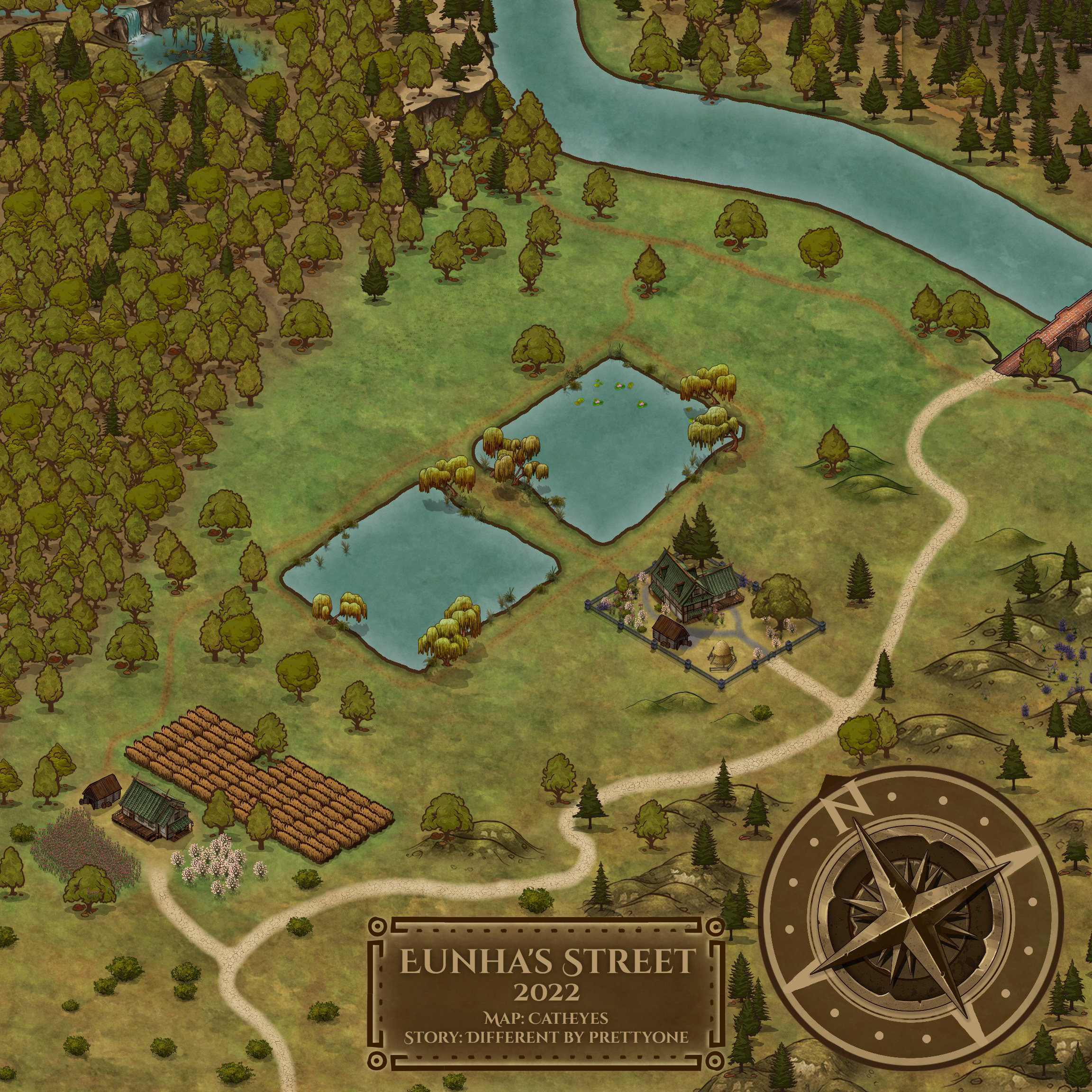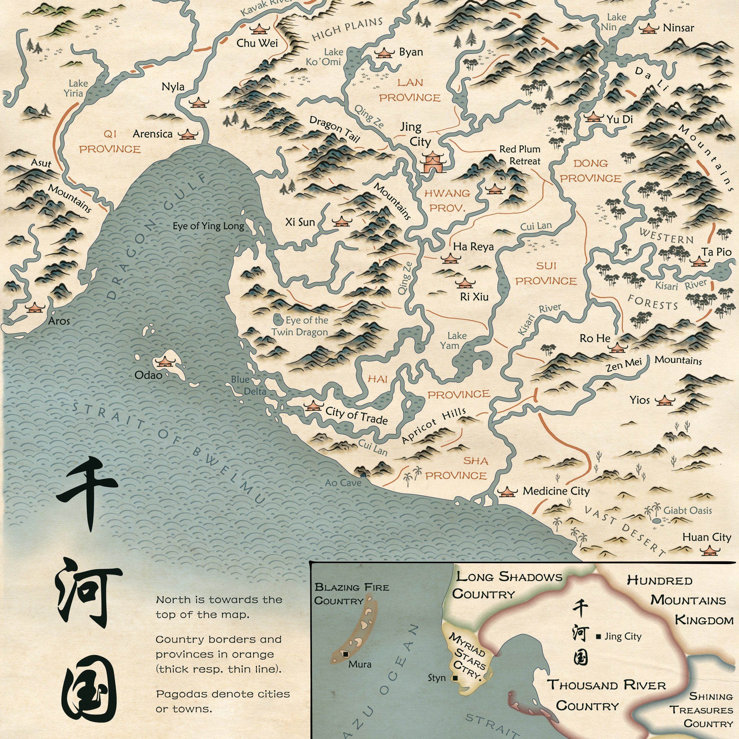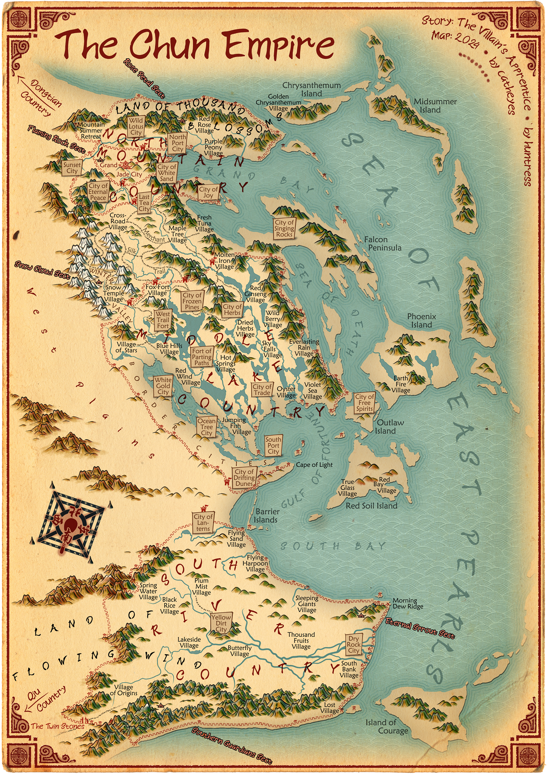
An Asian-themed fantasy map for the web novel The Villain's Apprentice by huntress on Wattpad.
About the WEb Novel Behind the Map
Dana, an assistant feature writer of the best-selling newspaper of the country, suddenly finds herself in a parallel world resembling ancient China after she was inspecting a mysterious, ancient book in the restricted section of the city library. In this world, where some people, called 'awakened ones', have qi, where sects and martial arts abound, and where everyday life follows dizzying customs and traditions; in this world, she is called Da Xia and is just being sold as a maidservant to warrior Yong Jie - the main lead of the book. And the only way to go back home seems to be to stick to him and ensure he gets a happy ending with his female lead. But as we all can imagine, things won't be as simple...
What sounds like the up and coming romance-fantasy-adventure drama of 2024 is actually a story called The Villain's Apprentice (on Wattpad) by my absolutely favourite webnovel writer huntress.
Exploring the Map
Best exploring experience is on a big screen because you can see more details there. You can also click on the map itself (works on small screens too, but big ones are better) to get a close up view of the map. Here are some questions or features to look for in the map to get you started with exploring the map:
First of all, if you have read the web novel, can you trace Dana's and Yong Jie's journey?
Can you locate the five Sects of the Chun Empire?
Where are the tombs of the empire's royal family located?
HINT: A city near the capital is named after it.
SOLUTION: At the City of Everlasting Peace in North Mountain Country.
HINT: A city near the capital is named after it.
SOLUTION: At the City of Everlasting Peace in North Mountain Country.
Where does the Chun Empire get their salt from?
HINT: In ancient times, salt was as precious as gold.
SOLUTION: From the White Gold City in Middle Lake Country.
HINT: In ancient times, salt was as precious as gold.
SOLUTION: From the White Gold City in Middle Lake Country.
If you wanted to set up a herb trading business, would you invest in ships or carriages for transportation? What if you wanted to set up a fox fur business instead?
HINT: Moving cargo on ships, even smaller river ships, is much more efficient than using carriages, as bigger volumes can be transported.
SOLUTION: In ships for herb trade since there is a direct water way from the City of Herbs to Grand Jade City, and into carriages for fox fur, as there is no direct waterway connection.
Your family lives in the capital Grand Jade City. Your aunt is worried because her son hasn't come back home in days. He is nowhere to be found in the city's pleasure houses, gambling dens, etc. that he likes to frequent, either. You know he doesn't like to travel beyond North Mountain Country. Where would you go look for him?
HINT: He found a pleasure house outside Grand Jade City.
SOLUTION: In the City of Joy in North Mountain Country.
HINT: He found a pleasure house outside Grand Jade City.
SOLUTION: In the City of Joy in North Mountain Country.
Where to find an active volcano with flowing lava?
HINT: A village is named after the lava flowing from the volcano.
SOLUTION: On Phoenix Island near Earth Fire Village.
HINT: A village is named after the lava flowing from the volcano.
SOLUTION: On Phoenix Island near Earth Fire Village.
An Ancient Chinese Compass
Ancient Chinese maps didn't really have a compass. However, there was some empty space on the map, so I decided to "invent" one. In fact, the compass was invented in China. Knowledge of magnetism in China dates back to at least the 1st millennium BCE, mentioning legends of a south‑pointing chariot. The first magnetic tools are dated 1st century BCE to 1st century CE. However, these early compasses weren't used for spatial navigation, but for divination/feng shui. Nevertheless, these compasses had a south-facing laddle. So, I designed the map's compass after these feng shui compasses.
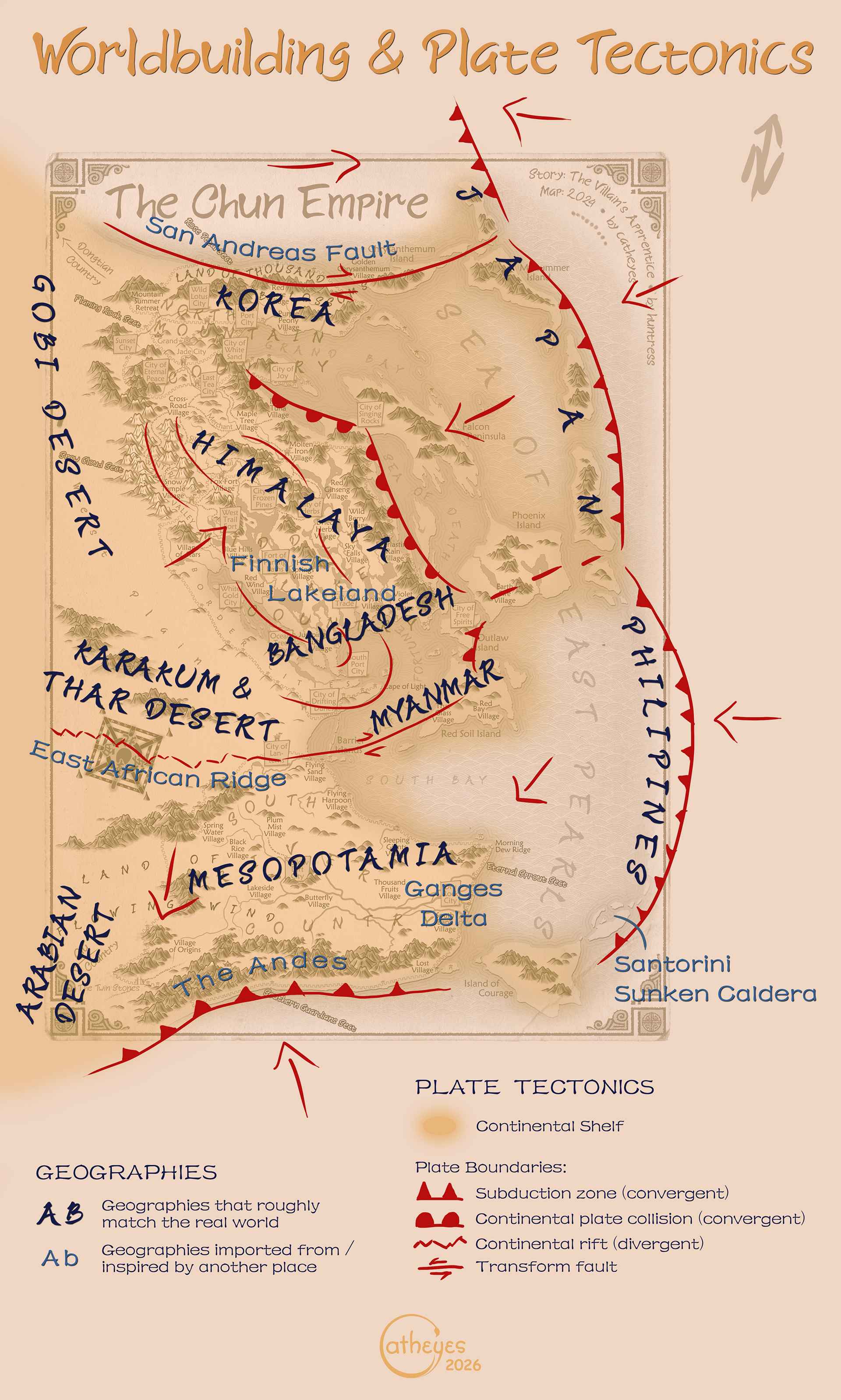
Worldbuilding
The Chun Empire's geography is based on a rotated and distorted version of the southern Eurasian continent - from the Arab peninsula to Japan. However, the climate and vegetation does not always match the corresponding areas in the real world. South River Country has lush vegetation, a subtropical climate, and many rivers. Middle Lake Country is a place with lots of (big) lakes on high plains where it's not very warm. It is something like a mixup of the Finnish Lakeland (with lots of pine trees) and the Himalayas. The Merchant Silk Trail area has a temperate climate. It is a rocky, mountainous area with coniferous and deciduous forests as a transition between the high plains in the south to lower lands in North Mountain Country. North Mountain Country has a colder temperate climate with distinct four seasons, not too dry and not too humid.
To make it work, I had to be creative with the plate tectonics (see image below). For example, the Himalayan system in the Chun Empire bends landward at "Bangladesh/Myanmar" rather than towards the sea as it does in the real world. As a result, I had to transplant a continental rift (like the East African Ridge) next to where the Karakum and Thar deserts would roughly be. Similarly, the Andes served as an inspiration for the large mountain range in the very south.
The biggest challenge were the many big lakes of Middle Lake Country. Where should all that water run off to? Unless the are salt lakes (which they aren't), some big rivers are needed to drain them. My first idea was through South River Country, as that place has lots of rivers too. But that would require the rivers to pass through the desert, which then wouldn’t be a desert anymore. So that wasn't an option.
I then made a draft, where these rivers flowed into this big peninsula east of the "Himalayas". But that peninsula would have been one of the most fertile areas where abundant life and thriving economies would grow (think the coastal areas of China, Thailand, Cambodia, or Vietnam). Consequently, this peninsula would have been one of the prime interests for the Chun Empire and it wouldn’t make much sense for it to be outside the three countries. So that option got scratched too.
Eventually, I went with the "Finnish Lakeland option": no rivers and the lakes go up to the coastline. Because of the high plains, this means though that there are significant changes in altitude between the lakes and many waterfalls. Neither of them are very apparent in the map though. Hypsometric colouring and contour lines weren't really a thing in ancient Chinese maps. And waterfalls are too small to show up in small-scale maps. However, the white coloured mountains and the mountains with white peaks indicate where the truly high peaks are located. And the most spectacular (i.e. highest) waterfall made it into the map through the village situated next to it: Sky Falls Village.
This option has its loopholes though, and there are other inconsitencies I couldn't reconcile either. But I deemed the overall system good enough to make it somewhat believable. Plus, it's a world with qi, "so you can actually get away with anything!" - to quote the author's smart advice.
Thanks
Huntress' stories were what pulled me into the AFF community and subsequently dramaland more than a decade ago. Her stories and the community there were what kept me sane during my years at university. Thus, I still can't believe I actually got to make a map for her now; it is such an honour! I had lots of fun making it: taking a deep-dive into the story, the world she created, and letting my own imagination run wild in it! Thank you, dear huntress, for giving me this opportunity!!! And also for being patient with me, since it took such a long time to finally finish it! ❤️
Credits
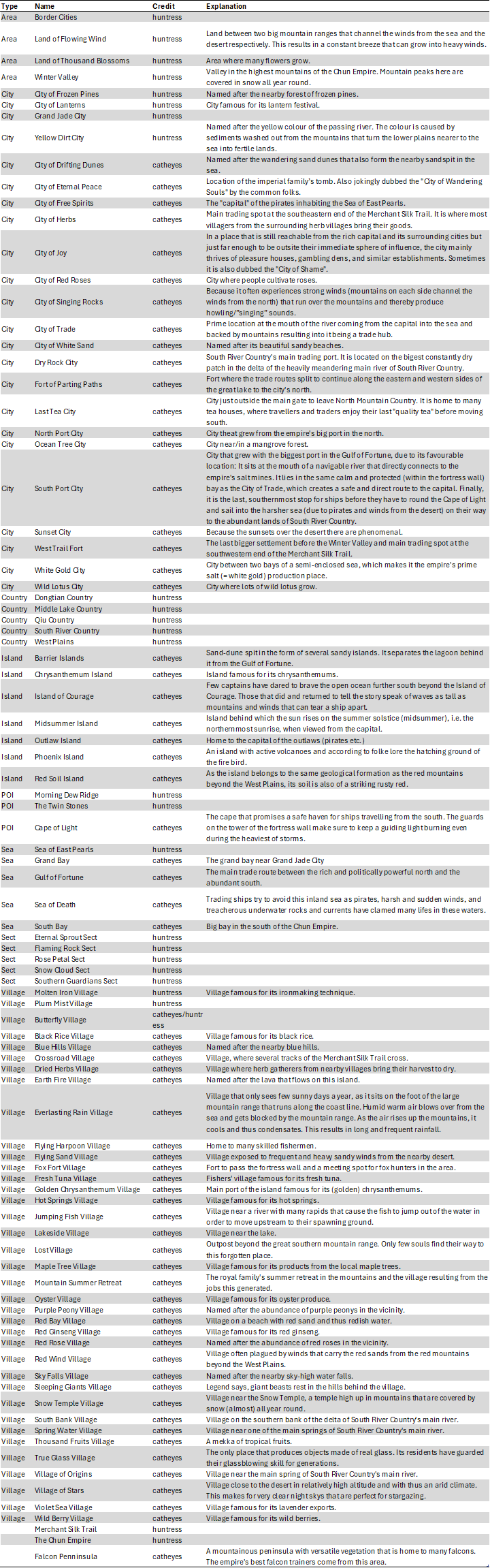
Huntress provided me a detailed account of the various geographical elements that feature in her story, including how they are spatially related and with hints regarding vegetation, climate or special features. For example: "At the eastern part beyond one of the roads of Merchant Silk Trail is the Molten Iron village which is a village at the at the bottom of a gorge with a steep, rocky path (it’s at the bottom of a cliff). The village has a stream passing through it. The northern and southern part of the village are lined by dense trees." She also gave me feedback on the drafts I made based on this account and regarding the look-and-feel of the map. As for coming up with names for places that were not mentioned in the story, I was left with quite a lot of creative freedom. The table below lists all the place names, their credits, and the worldbuilding considerations behind them (if I know them).
Sources
The map was created using Adobe Photoshop and Illustrator. Most of the map was painted by myself using a Wacom drawing pad. However, I have used a few brushes from StarRaven's Sketchy Cartography Brushes and the Simple Ink Map Brushes pack, if only as inspiration.